
60 V-BUDEM: a vector-based Beijing urban development model for simulating urban growth
ZHANG Yongping, LONG Ying

BUDEM (Beijing Urban Development Model) is a raster-based Cellular Automata (CA) model for supporting city planning and policies evaluation in Beijing. In this paper, we developed a vector-based version of BUDEM (V-BUDEM). In this model, urban space consists of irregular parcels, and a parcel’s neighborhood is defined as all parcels surrounding it within a certain distance. Additionally, a framework of parcel subdivision was adopted to subdivide existing parcels. After describing the conceptual model of V-BUDEM, including the parcel subdivision framework, we tested it in Beijing’s Yanqing Town for simulating urban growth from 2010 to 2020. Results show the V-BUDEM can be used to predict urban growth scenario, and prove the validity of our parcel subdivision framework. The main contributions of this study are as follows: (1) the model adopts a vector-based CA method using land parcels to represent urban space, composing the landscape a user would perceive as meaningful, and can simulate urban growth in a way more close to real world situation; (2) the model integrates a process of parcel subdivision, and the proposed parcel subdivision framework comprehensively considered the impacts of existing parcel boundaries in the existing land use map and planned parcel boundaries in the urban plan, and developed a straight-forward and automatic parcel subdivision tool, included in the framework as the fourth step, to partition existing large parcels; (3) compared with other urban models, V-BUDEM is developed specifically to identify policies required for implementing the planned urban form desired by planners and decision makers.
59 Finding public transportation community structure based on large-scale smart card records in Beijing
GAO Song, LONG Ying

Public transportation in big cities is a crucial part of urban transportation infrastructures. Exploring the spatiotemporal patterns of public trips can help us to understand dynamic transportation patterns and the complex urban systems thus supporting better urban planning and design. The availability of large-scale smart card data (SCD) offers new opportunities to study intra-urban structure and spatial interaction dynamics. In this research, we applied the novel community detection methods from the study of complex networks to examine the dynamic spatial interaction structures of public transportation communities in the Beijing Metropolitan Area. It can help to find the ground-truth community structure of strongly connected traffic analysis zones by public transportation, which may yield insights for urban planners on land use patterns or for transportation engineers on traffic congestion. We also found that the daily community detection results using SCD are different from that using household travel surveys. The SCD results match better with the planned urban area boundary, which means that the actual operation data of publication transportation might be a good source to validate the urban planning and development.
58 Implementation evaluation of urban growth boundaries: An analytical framework and case study of Beijing
LONG Ying, HAN Haoying, Shih-Kung Lai

Most existing studies on urban planning implementation (UPI) evaluation examine the conformity between planned and observed spatial urban development. The results are, however, typically too general to provide adequate policy recommendations for planners and researchers. The stages between creating a plan and its outcome are seldom discussed in detail, primarily because of the absence of an applicable analytic framework and data. In the present paper, we propose a framework for UPI evaluation which provides an in-depth and accurate application to show how the conceptual framework for assessing conformance and performance of plans proposed by Hopkins (2012) could be applied in practice. We examined the degrees of conformance and performance between an urban master plan, detailed plans, development permits and observed development outcomes, using Beijing as an example. The results reveal discrepancies between all basic stages of plan implementation, and the poor planning implementation was primarily due to the existence of large areas of development without development permits. Moreover, there was clear cross-referencing in the planning implementation process, which undermined the formal planning implementation procedures. These results suggest that the poor match between a plan and its outcomes may result from poor plan using, not poor planning. Therefore, attention needs to be paid not only to creating plans but also to monitoring the performance of various levels of plans and development permits in the UPI.
Please email to Dr Ying Long for the full paper: longying1980(at)gmail(dot)com
57 Early birds, night owls, and tireless/recurring itinerants: An exploratory analysis of extreme transit behaviors in Beijing, China
LONG Ying, LIU Xingjian, ZHOU Jiangping, CHAI Yanwei

This paper seeks to understand extreme public transit riders in Beijing using both traditional household survey and emerging new data sources such as Smart Card Data (SCD). We focus on four types
of extreme transit behaviors: public transit riders who (1) travel significantly earlier than average riders (the ‘early birds’); (2) ride in unusual late hours (the ‘night owls’); and (3)
commute in excessively long distance (the ‘tireless itinerants’); (4) travel over frequently in a day (the ‘recurring itinerants’). SCD are used to identify the spatiotemporal patterns of these
three extreme transit behaviors. In addition, household survey data are employed to supplement the socioeconomic background and provide a tentative profiling of extreme travelers. While the
research findings are useful to guide urban governance and planning in Beijing, the methods developed in this paper can be applied to understand travel patterns elsewhere.
56 Evaluating the effectiveness of urban growth boundaries using human mobility and activity records
LONG Ying, HAN Haoying, TU Yichun, ZHU Xianfan

We proposed a methodology to evaluate the effectiveness of Beijing’s Urban Growth Boundaries (UGBs) using human obility and activity records (big data). The research applied data from location
check-in, transit smart card, taxi trajectory, and residential travel survey. We developed four types of measures to evaluate the effectives of UGBs in confining human activities and travel
flows, to examine the conformity of urban activities with the planned population, and to measure the activity connections between UGBs. With the large proportions of intra- and inter- boundary
travel flows and an overwhelming majority of check-ins inside the UGBs, the research concluded that Beijing’s UGBs were effective in containing human mobility and activity. However, the
connections between UGBs, indicated by the spatial differentiation of the travel flows, were not consistent with the plan’s intention and strategy. It indicated the potential underdevelopment of
the public transit serving several new cities.
55 Predictability of road traffic and congestion in urban areas
WANG Jingyuan, MAO Yu, LI Jing, WANG Wenxu, LI Chao, XIONG Zhang

Mitigating traffic congestion on urban roads, with paramount importance in the urban development, reduction of energy consumption and air pollution, depends on our ability to foresee road usage and traffic condition pertaining to the collective behavior of drivers, raising a significant question: to what degree is road traffic predictable in urban areas? Here we rely on the precise record of daily vehicle mobility based on GPS devices installed in taxis to uncover the potential daily predictability of urban traffic patterns. Using the mapping from the degree of congestion on roads into a time series of symbols and measuring its entropy, we find a relatively high daily predictability of traffic condition despite the absence of any a priori knowledge of drivers’ origins and destinations and quite different travel patterns between weekdays and weekends. Moreover, we find a counterintuitive dependence of the predictability on travel speed: the road segment associated with intermediate average travel speed is most difficult to be predicted. We also explore the possibility of recovering the traffic condition of an inaccessible segment from its adjacent segments with respect to limited observability. The highly predictable traffic patterns in spite of the heterogeneity of drivers’ behaviors and the variability of their origins and destinations enable the development of accurately predictive models for eventually devising practical strategies to mitigate urban road congestion.
54 Where to harvest social capital outside the ivory tower: Visualizing university students’ trip destinations with smartcard data
WANG Mingshu, ZHOU Jiangping, LONG Ying

Cities are regarded as the greatest invention that makes us richer, smarter, greener, healthier and happier (Glaeser, 2012). Part of the secret of successful cities lies in innovations facilitating by face-to-face interactions. Interactions enhance the social capital of interacting parties. Universities are where innovations, face-to-face interactions and social capital are commonplace. But universities are not islands in the open sea of the social and economic transformations. Traffic, information and financial flows between universities and other locations can be used to show connections between the ivory tower and the society. In our studies, we use the weekday smartcard data from April 6, 2010 to April 9, 2010 (totally 158,262 transit trips, including bus-only, bus plus subway and subway-only trips) to identify and profile the most popular destinations of the student riders from the “985 universities” and associated transit trip flows in Beijing. “985 universities” are the top 39 universities designated by the Chinese Central Government. There are eight of them located in Beijing, making the city home to the most “985 universities” in China. We define “popular destinations” as bus and subway stations where a student transit rider stays longer than one hour before he starts a second transit trip.
We argue that the popular destinations are equally important places like university campuses where people interact, innovate and increase their social capital. Associated transit trip flows show, at least partially, how universities and colleges are connected to popular destinations and where the strongest ties between them exist. Figures 1 to 3 visualize the popular destinations and associated ties. Not surprisingly, areas adjacent to the“985 universities” campuses such as Zhongguancun (“A” in Figure 1) contain the most popular destinations. The financial district (Xidan, “B” in Figure 1) and the central business district (Guomao, “C” in Figure 1) have the second most popular destinations. Other areas such as Yonghegong, Liuliqiao, Sanyuanqiao and Asian Game Village (“D” to “G” in Figure 1) also have a notable number of popular destinations. These areas have a high density of office buildings, shopping malls and/or restaurants. Figure 2 visualizes the strongest ties between the university campuses and the popular destinations. Strong ties exist between the universities and Guomao and between the universities and Yonghegong. Most of the strongest ties are within the 3rd ring road, where there are the highest concentration of high-income residents, high-profile entities and high-paying jobs in Beijing. But somewhat to our surprise, the ties between the“985 universities” are not among the strongest. Figure 3 shows where the students had been to after leaving their respective campuses and adjacent areas. The student riders did go to numerous destinations, similar to the general riders (Roth et al., 2011). But they rarely went to the areas south of the 3rd ring road, where there has been the highest concentration of low-income residents and low-paying jobs in Beijing. As a whole, therefore, our studies of university student riders indicate that there exist only weak ties between the top universities and the most disadvantaged areas in Beijing. This is slightly different from what Roth et al. (2011) has found about the general riders in London. Per Roth et al. (2011), most stations in London control their own regions and seem to have their own distinctive basins of attraction. In Beijing, student riders from top universities tend to favor or avoid certain stations or regions, regardless the distance.
53 Jobs-housing balance: Measurement, patterns, and social Costs——A case study in Beijing
ZHENG Siqi, XU Yangfei, WU Jing, YU Du, XU Junyan, ZHANG Xiaonan, ZHANG Bo

52 Spatially heterogeneous impact of urban form on human mobility: Evidence from analysis of TAZ and individual scales in Beijing
LONG Ying, SHEN Yao, YAO Xiaobai, GAO Sangni

The influence factors on human mobility (e.g. travel length/distance, time and count) are increasingly recognized as essential components of traffic assignment for urban sustainability. But most of the existing studies were based on individual samples, therefore neglected the spatial heterogeneity of mobility patterns. This study performs an examination of the spatially varying impacts of urban form and socioeconomic attributes on human mobility (average travel distance in this chapter) in the Beijing Area based on the Household Travel Survey in 2005. By using mixed Geographically Weighted Regression (MGWR), we incorporate the spatial stationary and non-stationary in one model to estimate the influence surfaces of elements that maters in residential mobility on the Traffic Assignment Zone (TAZ) level. Compared with the results produced by Ordinary Least Square (OLS) and Spatial Auto-Regression (SAR), the outputs of MGWR indicate that semi-parametric model has better performance in presenting the spatial variation of predictive factors’ impacts. The maps further show that urban form features do impact people’s mobility to various extents, both positively and negatively. Additionally, this study also yields that the analysis on the TAZ level by MGWR reveals better prediction in the spatial variability of local estimates in comparison with OLS analysis for the personal level data in the same survey. This empirical effort helps us to understand that people’s mobility behaviors can be influenced by spatially exploring relevant variables of urban form.
51 What hidden benefits have civil servants gained from their houses? An empirical study based on large sample micro survey data in Beijing
ZHANG Yingjie

This paper tests using large sample micro survey data from Beijing whether civil servants have been enjoying some hidden benefits associated with their houses. Although the issue of social inequality or housing inequality has been discussing in previous studies, very few has mentioned the inequality from the perspective of occupation, especially the inequality between civil servants and workers in other industries. We find that civil servants in Beijing do enjoy hidden benefits from their houses in three aspects. First, they enjoy a better “job-housing” balance status as they commute 2.1 minutes shorter to work; second, they do have a higher degree of overall accessibility to high-quality urban public services. What‟s more, the communities where a relative larger proportion of civil servants live together, which may indicate complexes special built for civil servants, will generate an additional 5% premium in housing price, even after controlling for community demographic composition. We infer this may due to some unobservable high-quality facilities built specially for the civil servants, or residents‟ willingness to pay for living together with these civil servants as an important indicator of social status. These above findings are robust when compare civil servants with other workers in state-owned enterprises.
For the full paper, please address your request to Mr Yingjie Zhang via zhang-yj06@mails.thu.edu.cn
50 Big data for intrametropolitan human movement studies: A case study of bus commuters based on smart card data
ZHOU Jiangping, WANG Mingshu, LONG Ying

Unlike the data from traditional sources, there have not been standard ways to validate the quality and reliability of information derived from big data. This article argues that the theory of
urban formation can be used to do the validation. In addition, the information derived from big data can be used to verify and even extend existing theories or hypotheses of urban formation. It
proposes a general framework regarding how the theory of urban formation can be employed to validate information derived from smart card data and how the validated information can supplement
other data to reveal spatial patterns of economic agglomeration or human settlements. Through a case study of Beijing, it demonstrates the usefulness of the framework. It also describes the bus
commuters’ subcenters’ characteristics of Beijing based on smart card data.
49 The effects of Beijing’s urban growth boundaries on urban development
GU Yizhen, LONG Ying

We examine the eects of Beijing's urban growth boundaries (UGBs) on urban development. Using data on land use permits issued between 2003 and 2010, we nd that this policy have to some extent curtailed urban development outside UGBs. The development probability of parcels located just outside UGBs was one to six times smaller than those just inside UGBs. Our identication strategy that combines both a dierence in dierences (DID) approach and a regression discontinuity design (RDD) approach can well address two challenging issues in the empirical work: the existence of confounding policies and the endogeneity of the UGB's location. Using only a DID approach fails to exclude the eects of policies implemented along with UGBs, while using only an RDD approach cannot exclude the inuence of factors that happen to have a spatial discontinuity at the boundaries. Furthermore, there have been lots of doubts about the eectiveness of urban plans in China, which sometimes are described as \Drawn on the map, and Hung on the wall." Our nding shows that, at least in Beijing, urban planning plays a signicant role in shaping a city.
For the full paper, please address your request to Dr Ying Long via longying1980@gmail.com
48 Spatial structure and functional location choice in the light of big data
YANG Tao
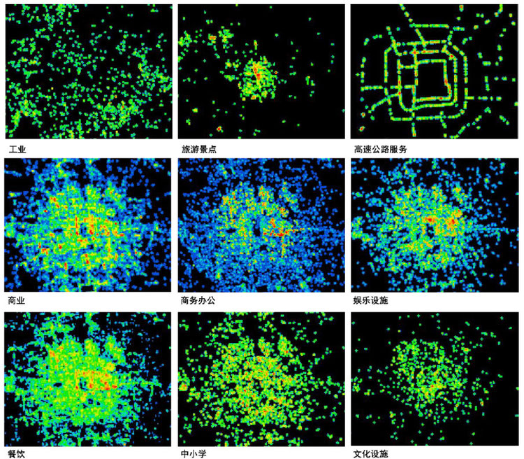
The availability of big data provides a new angle on investigating whether, and if so, how far urban spatial morphology intrinsically interacts with its functions. This article, using a pilot
study of the Beijing city, first seeks to explore spatial configuration - the complex relation between any pair of individual spaces regarding other contextual spaces – of urban network collected
from Baidu, and the aggregation patterns of Baidu’s POI (Point of Interest) regarding functional classification. And then, it focuses the attention on conducting a statistical correlation between
the configurational patterns of urban network and the aggregation patterns of functions. Based on these studies, it argues that different functional points, according to their scales, client
groups, cultures and management perspectives, adopt and adapt the differently structured layouts and meanwhile seek the differently valued locations at different radii. For example, small-scale
commercial-oriented facilities tend to highly aggregate at the places well-structured at different radii, usually called the active centres; medium-scale commercial-oriented facilities are more
likely distributed at the well-structured sites only at the large radius, termed the generic centres; and large-scale commercial-oriented facilities, such as shopping malls, have higher
possibility of being situated at the spaces that are not well-structured at any radii, and such space can be named non-spatial attractors. In this sense, the different functional aggregation
patterns can be argued to more or less reflect, and even correspond to, the different ways of structuring spatial layouts at the levels of the whole city and its parts.
47 Social sensing: A new approach to understanding our socio-economic environments
LIU Yu, LIU Xi, GAO Song, GONG Yi, KANG Chaogui, ZHI Ye, CHI Guanghua, SHI Li

The emergence of big data brings new opportunities for us to understand our socio-economic environments. We coin the term “social sensing” for such individual-level big geospatial data and
the associated analysis methods. The word “sensing” suggests two natures of the data. First, they can be viewed the analogue and complement of remote sensing, since big data well capture
socio-economic features for which the conventional remote sensing data do not work well. Second, in social sensing data, each individual plays the role of a sensor. This article connects social
sensing with remote sensing and points out the major issues when applying social sensing data and associated analytics. We also suggest that social sensing data contain rich information about
spatial interactions and place semantics, which go beyond the scope of traditional remote sensing data. In the coming big data era, GIScientists should investigate theories in using social
sensing data, such as data representativeness and quality, and develop new tools to deal with social sensing data.
46 Population spatialization and synthesis with open data
LONG Ying, SHEN Zhenjiang

Individuals together with their locations & attributes are essential to feed micro-level applied urban models (for example, spatial micro-simulation and agent-based modeling) for policy evaluation. Existed studies on population spatialization and population synthesis are generally separated. In developing countries like China, population distribution in a fine scale, as the input for population synthesis, is not universally available. With the open-government initiatives in China and the emerging Web 2.0 techniques, more and more open data are becoming achievable. In this paper, we propose an automatic process using open data for population spatialization and synthesis. Specifically, the road network in OpenStreetMap is used to identify and delineate parcel geometries, while crowd-sourced POIs are gathered to infer urban parcels with a vector cellular automata model. Housing-related online Check-in records are then applied to distinguish residential parcels from all of the identified urban parcels. Finally the published census data, in which the sub-district level of attributes distribution and relationships are available, is used for synthesizing population attributes with a previously developed tool Agenter (Long and Shen, 2013). The results are validated with ground truth manually-prepared dataset by planners from Beijing Institute of City Planning.
45 Population exposure to ambient PM2.5 at the subdistrict level in China
LONG Ying, WANG Jianghao, WU Kang, ZHANG Junjie

Fine particle pollution is a major public health concern in China. This paper assesses China’s potential population exposure to PM2.5 at the subdistrict level, the smallest census unit with public information. Using both ground-based measurements and satellite-based Aerosol Optical Depth retrievals, we estimate subdistrict-level daily PM2.5 concentrations by means of the block cokriging approach. Our results reveal that China’s population-weighted annual average PM2.5 concentration during April 08, 2013 and April 07, 2014 is nearly 7 times the annual average level suggested by the World Health Organization (WHO). About 1,322 million people, or 98.6% of China’s total population, are exposed to PM2.5 at levels above WHO’s daily guideline for longer than half a year. We also simulate the effects of China’s most recent action plan on air pollution control. The simulation results demonstrate that the population exposed to PM2.5 above China’s daily standard for longer than half a year will be reduced by 85% if the plan can achieve its target by 2017. Nevertheless, PM2.5 will be still at a harmful level to public health, which calls for additional effort in pollution control.
44 Profiling underprivileged residents with mid-term public transit smartcard data of Beijing
LONG Ying, LIU Xingjian, ZHOU Jiangping, GU Yizhen

Mobility of economically underprivileged residents in China has seldom been well profiled due to privacy issue and the characteristics of Chinese over poverty. In this paper, we identify and characterize underprivileged residents in Beijing using overwhelmingly available public transport smartcard transactions in 2008 and 2010, respectively. We regard these frequent bus/metro riders (FRs) in China, especially in Beijing, as economically underprivileged residents, which has been proved by (1) the household travel survey in 2010, (2) a small-scale survey in 2012, as well as (3) our interviews with local residents in Beijing. Places of residence and work of cardholders are identified using the SCD in 2008 and 2010, respectively, in which a cardholder’s unique card ID kept the same. We then profile all FRs identified into 20 groups in terms of their place of residence variation (change, no change), workplace variation (change, no change, find a job, lose a job, and jobless all the time) during 2008-2010 and housing place in 2010 (within the fourth ring road or not) for deriving policy implications for practitioners. The underprivileged degree of each FR is then evaluated using the 2014 SCD. The potential bias and contribution is finally summarized. To the best of our knowledge, this is the first study for understanding long- or mid-term urban dynamics using immediate “big data”, and also for profiling underprivileged residents in Beijing in a fine-scale.
43 Lessons from Europe: Challenges and Opportunities of Chinese Urbanism in Transition – A dialogue with Professor Sir Peter Hall
SHEN Yao, LIU Lixun
This interview stems from two events happened in the begging of 2014: on one hand, Professor Sir Peter Hall published his latest book – Good City, Better Life: How Europe Discovered the Lost Art of Urbanism – which has considerably drawn lots of attention in the international filed of urban planning; on the other hand, Chinese government just released the latest national planning strategies for the following 6 years – National New Urbanisation Planning (2012-2014)- which has described the detailed developing indices for the urbanisation in the near future. The former one is related to the thoughts of a well-known scholar about the challenges that British cities are facing, including economy balance, housing development, integrated planning of transport and land use, sustainable neighbourhood development and good mechanism of urban regeneration (Hall, 2014), whereas the latter one is about the adjustment of aims of urbanisation in the biggest developing country. The new developing goals are explicitly put into words covering five topics as the following: improving the quality of urbanisation, optimizing the spatial structures of metropolitans, promoting the sustainability, ameliorating the public service and completing the market mechanism (Chinese National Council, 2014). It is not hard to recognise that these two events concern some similar aspects of urbanisation. Hence, what we really care here is whether the proposed “New Urbanisation” in China could learn from the art of urbanism in Europe.
This interview starts from a discussion about the necessity and possibility for Chinese cities learning from the present experience in Europe. In the main part, two key issues emerging not only in Chinese urbanism but also international modernisation are addressed: the development of megalopolis and the population urbanisation. Based on the Prof. Sir Peter Hall’s recent thoughts of European cities, this interview explores the relevant issues in proposed new urbanisation planning and highlights the benefits of the lessons from Europe.
42 A retrospect and prospect of urban models
LIU Lun, LONG Ying, Michael BATTY
Based on an interview to Mike Batty, a leading scholar in urban modelling, the paper reviews the history of urban models, comments on their present developments and pictures their prospects. The first section briefly overviews the family trees of urban models and then looks further into the causes for their failure in planning application in the first upsurge of research in the 1960s and 1970s. The second section summarizes the current development of urban models nowadays, which can be counted as the second upsurge of research. It is estimated that more research attention will be paid to building dynamic, disaggregate, micro and problem-oriented models, with a combination of top-down and bottom-up modelling methods, which can be more capable of tackling the growing urban complexity and uncertainty. Meanwhile, the ‘big data era’ also poses more opportunities for the development of urban models. The last section introduces three new trends in the theoretical, educational and research development of urban models, which are the idea of ‘new science of cities’ by Mike Batty, the start-up of quantitative urban research education and the establishment of Beijing City Lab.
41 Big Models: From Beijing to the whole China
LONG Ying

This paper proposes the concept of big model as a novel research paradigm for regional and urban studies. Big models are fine-scale regional/urban simulation models for a large geographical area, and they overcome the trade-off between simulated scale and spatial unit by tackling both of them at the same time enabled by emerging big/open data, increasing computation power and matured regional/urban modeling methods. The concept, characteristics, and potential applications of big models have been elaborated. We address several case studies to illustrate the progress of research and utilization on big models, including mapping urban areas for all Chinese cities, performing parcel-level urban simulation, and several ongoing research projects. Most of these applications can be adopted across the country, and all of them are focusing on a fine-scale level, such as a parcel, a block, or a township (sub-district), which is not the same with the existing studies using conventional models that are only suitable for a certain single or two cities or regions, or for a larger area but have to significantly sacrifice the data resolution. It is expected that big models will mark a promising new era for the urban and regional study in the age of big data.